Reading the signs of climate change with the Belu Community

Down to Earth 87, December 2010
This article is based on a presentation by YMTM (Yayasan Mitra Tani Mandiri) held at a meeting of Caritas Australia partners, in October 2010. DTE also interviewed YMTM representatives Joseph Asa and Hilaria Kou.
Communities in seven villages in Belu district, East Nusa Tenggara (NTT) province, have just finished doing research on climate change, its impacts, and adaptation strategies. The selected villages are located in the southern lowlands in Central Malaka subdistrict, and in the northern highlands in Lamaknen subdistrict. The observation posts take their names from the sub-district capitals: Betun for Central Malaka and Weluli for Lamaknen sub-district. The approach used was community-based participatory rural appraisal, meaning that the resulting study is a collection of the communities'opinions about, and experiences of, climate change.
Rainfall
One of the indicators used to conduct this study is the amount of rainfall between 1999 and 2009. To facilitate the calculation, the study uses criteria issued by Indonesia's Meteorology and Geophysics Agency (BMG): daily rainfall is added up over the course of ten days and then its average calculated. This results in three ten-day periods per month, and 36 per year.
From these calculations the communities concerned can precisely discern the shift in the beginning of the rainy and dry seasons. For example, at the Weluli observation post, the duration of the rains has been relatively constant during the last 20 years at 15 ten-day periods (5 months) although there was a shift in the start of the rainy season from the 12th ten-day period to the 11th. At the same time, at the Betun post, the duration of the rains decreased from 9 ten-day periods (3 months) to 7 ten-day periods (2 months 10 days). Meanwhile, according to the local community, the rains' duration has gone down from 8 months to 5 months in the higher-lying areas (Maneikun, Lakanmau, Maudemu, Faturika, Dubesi) and from 9 months to 5 months in the southern coastal areas. However, the southern region also experiences a second rainy season (called Udan Lorofalin or Udan Knau) around June/July (see table).
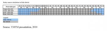
According to the local population, the total annual rainfall has seen an overall increase during the past 30 years, but uneven distribution of the rain has led to problems regarding the appropriate selection of crops to be planted for food or cash. People complain that the rain is now different than in the past; it is difficult to forecast and traditional indicators no longer work effectively.
The local population also feels that air temperature has been increasing during the past 20-30 years. Night temperatures, which used to be cool, are no longer so, including during the months of June and August, which are usually very cool. The same thing is also happening in highland regions like Maudemu which used to be much cooler - now the difference is negligible. Winds are generally uncertain and therefore difficult to predict. In the previous period, the wind was either coming from the west or the east, but now wind direction as well as wind speed are erratic.
As people in Belu district, haven't had access to information about the global drivers of climate change, they have tended to look for local causes of climate change. They have attributed the changes to: 1) the decline or loss of local traditions and knowledge relating to the "calling" or "stopping" of the rain, of taboos/prohibitions (Ukun Badu), customary rules on grazing and land tenure, and of the appreciation and respect for customary rites and forests; and 2) the burning of forest and land; changes in consumption patterns, farming systems and animal husbandry; as well as attention to local wisdom and the biophysical environment not playing much of a role in young people's education.
Community focus groups are planning some measures as adaptation and mitigation strategies, such as forest protection and reforestation around water sources.
 (Dryland regreening map - source: YMTM)
Hilaria's experience as a field worker for YMTM
Hilaria has been a field worker since 1997 and currently works in a village in North Central Timor (TTU) district.
When she sets up farmers' groups the first step is to push for a Long Term Development Plan at the village government level. This aims to ensure that community programmes are integrated into the village programmes. If the village government is not prepared to do that yet, then YMTM usually asks permission to set up a group consisting of 5 to 6 people first who work on the garden arrangements.
There are usually 6 to 10 groups in per village.
In most cases, accounts of successful farmers taking part in the programme win over those within the community who are not yet convinced about the benefits. Such conversations and exchange of information are very effective in accelerating the restructuring of the village gardens.
“When we introduced terracing as a means of soil and water conservation to the community, people thought it was odd, even though planting these trees has so many functions for the soil. For example, planting Gamal can strengthen the soil and capture carbon which can be converted into nitrogen needed by the soil. Gamal can also be used as a green fertiliser. The leaves of the leguminous trees or shrubs contain nitrogen, and their wood can be used to make livestock pens, while the roots are able to capture nutrients so that the chemical fertiliser, urea, is no longer needed.”
“We always try things on a small scale with farmers first, and only if it works well, do we expand. In the past, field extension officers from the Department of Agriculture came in to train villagers to make liquid fertiliser, but they never came back to explain how to use it.”
“In one case, a woman tried using the fertiliser directly on her carrots, tomatoes and chilis, and the plants died as a result. Understandably, people no longer wanted to use liquid fertiliser.”
“When I arrived and tried to teach them how to make liquid fertiliser, they refused due to their previous negative experience. So I asked them to try to make liquid fertliser on a small scale from manure that is still wet, mixed with legume leaves and grass. This works as a natural pest control and fertilises the plants. In order to use the fertiliser, it has to be diluted with water. The farmers were pleased with the result and they are now using the fertiliser again.”
“The way in which we approach a village differs from case to case. In Humusu village, we approached the customary leader because the community depends on him. In other places we made our approach through the head of village or hamlet as appointed under the official government system.”
“For the region as a whole, we conduct a survey which asks: 1) has the village received insufficient attention? 2) who has previously helped the village/hamlet? 3) who has influence in the village? 4) what condition are the farms in? etc. Generally, the villages we work with are remote, dry and face serious challenges.”
|
Greening dry land Yayasan Mitra Tani Mandiri (YMTM) is a civil society organisations active in East Nusa Tenggara province. Its members have managed to develop agroforestry programmes and transform land in dry areas of three districts - Flores, TTU and Belu - into plantations that produce sufficient resources for the local community. YMTM has received several awards, among them the Community Based Forest Management (CBFM) Award (2006) and the Equator Prize from the United Nations Development Programme (UNDP) in 2010 for the successful implementation of new agricultural technology. Here are excerpts from an interview with Yoseph Asa. What are your criteria for selecting villages? We choose villages based on their location on very dry land. We believe that if we succeed in improving a dry area it will be easier for us to also enter less challenging areas. Our programme is based on improving soil fertility, so for the first three years we try to improve soil fertility. Traditionally, the local population recovers land by cutting the branches of certain trees and then planting them in the soil to increase soil fertility. Lamtoro, Gamal, Kaliandra, Flamenia, Desminiu and Turi are multifunctional trees, which not only improve soil fertility but also act as erosion barriers, provide fire-wood, protect other plants, and are sources of seeds and animal feed. For example, Turi and Lamtoro are used as feed for cattle. These plants have proven helpful in creating a micro-climate for farming communities. For example, during the rainy season, the branches and leaves of these trees are trimmed and used as an organic fertiliser. The purpose of pruning is to make sure that the crops planted between the trees get enough sunlight. In the dry season, the trees are left to grow so that the soil is kept moist. This technology has been proven as capable of increasing productivity in sustainable organic agriculture. Poor farmers living and working in difficult areas cannot afford chemical fertiliser and seeds, which is why we strive to make the most of locally available seeds. We never advise the use of chemicals unless there is a village already using them, and normally we would encourage them to switch to organic agriculture. Chemical fertilisers are risky for dry land use as they require large amounts of water. What are the economic benefits for the local people? Nowadays most people are able to sell seeds of trees to the local Forest Service office. They can also sell wood for construction to buyers from outside the area. Biodiversity is safeguarded by the planting of trees. New sources of water have appeared, and the number of birds in the areas has started to increase. Why has this agroforestry programme been so successful? Because we involve the communities from the beginning, and because these communities can support themselves. For example, they may find seeds in the forest and plant them in their own garden/field. We start our planning at the level of the family garden. Almost every farming family can draw a picture of how their own garden is planned. They need to do this to facilitate further planning. Each image of the family garden should include all three time horizons: short-term crops (around one year) for food; medium-term crops (3 - 5 years); and long-term such as timber for buildings. Although the land is dry in these places not all dry land technology can be used in the same way in all places. It must be adapted to the topography - the higher the location, the drier the village; lower-lying locations tend to be wetter. What we do when starting in a village is to listen to farmers recount their usual planting practices. We mustn't push any particular concept we are familiar with. Let's not imitate the government which in the past promoted the planting of cashew seedlings - a process that eventually failed because not all regions in NTT were suitable for growing cashews. What is your hope for the future? In the future we would like to scale up our programmes, from farmer to farmer and village to village. We want to expand into education and contribute our experience to agricultural schools and colleges.
|